22 February 2016
Participants:
UTokyo: Dr. Akiyuki
Kawasaki, Dr. Shimozono, Dr. Acierto, Masahiro Kambara, Shin Yonehara
JICA: Hiroyuki Okazaki
(SATREPS Project Coordinator at YTU)
YTU: Chit Bo Bo Win, Ye
Thu Aung (Master’s Student)
Myanmar Irrigation
Department: Mr. Tun Tun Win (Assistant Engineer, Waw Township), Mr. Ne Myo Htun
(Staff Officer, Thannapin Township)
 |
Figure
6. Locations of the flood protection
structures visited along the Bago-Sittang canal
|
 |
Figure
7. Initial Discussion at Tawa
Sluicegate (left) and downstream view Tawa Sluicegate (right) – Site 1 at
Figure 6
|
 |
Figure
9. Aba sluicegate with downstream (right)
and upstream (left) sides with manual gate closing mechanisms – Site 3 in
Figure 6
|
 |
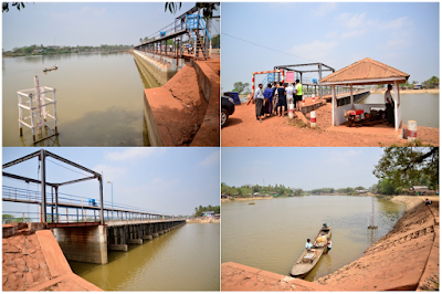
Figure
10. Downstream most bridge at Sittang
River near the river mouth – Site 4 in Figure 6
|
 |
Figure
11. Shangaing Sluicegate showing the
downstream side (left) and upstream side (right) – Site 5 in Figure 6
|

No comments:
Post a Comment