Wednesday, June 22, 2022

Research Progress: Water stress footprint analysis at the sub-national level in China

Hello, This is Zhao Han, a Ph.D. student in the Kawasaki Lab, and I am happy to introduce you to some small advances I have made in my research on the sustainable development of the Global Commons.

Human society depends on water for its survival and development, and global water demand has increased nearly eightfold in the past 120 years. The water crisis posed by severe water scarcity has threatened most of the world's countries and water scarcity has been identified as a key issue in the SDG goal 6.

The Planetary boundaries
From: Science

Freshwater use, as a key component of the planetary boundary, its fine regional studies are considered to be of great importance to the global system. Also an important component of the Global Commons assessment. In particular, China, the world's second-largest economy and one of the top water-scarce countries in the world, has an inconsistent spatial distribution of water. Indeed, it is the increasing inequality of water between regions and sectors that have led to a growing concern for water allocation policies within the country. We need to confront the chronic problem of mismatch between water supply and demand, and a comprehensive understanding of the issues related to water stress is crucial for it.

Based on the above issues, we are interested in answering the following questions: What are the Spatio-temporal patterns of water stresses embodied in China's trade at the provincial scale? How have these WSFs transferred with supply chains? 

We used the high-resolution CMRIO-EXIO model developed by ourselves to assess the water stress and blue water footprints of China. The IO model is a quantitative economic model that represents the interdependencies between different sectors of a national economy or different regional economies, additional columns can be added to the model to perform environmentally extended input-output analysis (EE-IOA). For example, information on fossil fuel inputs to each sector can be used to investigate flows of embodied carbon within and between different economies. Through this model, It can easily help us figure out the hotspots of the water stress footprint embodied in trades. 


First, the Spatio-temporal patterns and changes in water stress footprint are shown in the above figure. 

The Chinese consumption-based WSF accounted for 21% of the global total in 2017 (production-based is 23%). In addition, China's consumption-based BWF increased from 213 km3 in 2012 to 342 km3 in 2017, accounting for 17% of the global total in 2017. In terms of China's provincial accounting, as China's urbanization deepens, spatial disparities in production-based WSF are increasingly serious, with a striking division in WSF between the South and North. WSF embodied in production in Xinjiang (XJ), Hebei (HE), and Shandong (SD), provinces in Northern China, warrant attention. In comparison, consumption-based WSF is much higher than production-based WSF in more affluent provinces (e.g. Zhejiang (ZJ), Beijing (BJ), Tianjin (TJ), and Guangdong (GD)).


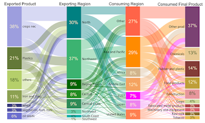
Then, our CMRIO-EXIO model also allows tracking of the international supply chains in the 8 regions of China back to each country and sector where impacts occur.

Water stress from China accounts for 13% of the total imported embodied water stress in the Row Asia and Pacific, followed by South Korea (12%) and Japan (9%). The above figure presents an aggregated supply chain of other regions' water stress outsourced to China. From the production perspective, the economies with the greatest impact on China's WSF are those in Row Asia and the Pacific, along with other major countries such as the US and Japan. The North and Northwest are the regions where other countries/regions transfer the most water stress through consumption (67% of China's total exports). Unlike the type of WSF on the supply chain of Chinese water stress outsourced abroad, which is mainly concentrated in food, WSF on the supply chain of water stress outsourced from abroad to China is spread across many industry types. In addition to agricultural cultivation, industrial products such as plastics and steel exported to meet the international chemical, construction, electromechanical, and other industries further contribute to water stress in Northern China.


More information can be obtained from the following paper: https://doi.org/10.1016/j.scitotenv.2022.156682

If you are interested in this, you are more than welcome to get in touch with us!


Sunday, May 22, 2022

現地視察:球磨川流域と川辺川ダムと、下筌ダムと

初めまして。昨年から川崎グループに入りましたM2の五十川(いそがわ)です。

4/23・24に開催されたアジア・太平洋水サミット(詳細は中村さんの投稿を参照)で熊本に訪れたついでに,25・26日にかけて2年前の豪雨災害を受けた球磨川流域と川辺川ダム建設予定地,建設の際に「蜂の巣城紛争」が起こった下筌ダムを訪れました。

コロナの影響もあり,個人的には研究室配属から3年目にして初の現地視察となりました。


◆25日:球磨川流域,川辺川ダム

池内グループM2の鈴木くんが強力な助っ人としてこの日から同行することに。

まずは球磨川を下流から上流部へと沿うようにして走りました。

下流域の八代市街地に訪れるまでは豪雨被害をあまり感じさせない状態でしたが…

熊本といえばこの方。びっくり!

いざ河川沿いを走ると状況は一変。2年前の豪雨災害とはいえ,路面崩落等による車線規制や河道内での工事は今もなお広範囲に渡り続いていました。土砂が積まれたトラクターや工事用車両が多く走っているのを見て,まだ完全に復興したとはいえない状況に何とも歯痒い気持ちでいっぱいでした。
さらに,並走するJRの線路が無残な状態のまま手がつけられていないのを見て,民間インフラ存続の厳しさを目の当たりにしました。被災前はSLが走っていたらしく,川沿いを走りながらSLが走る写真を見ると,何とでも復旧してほしいと感じました。

線路が隠れて見えない

他にも,仮設橋が至るところに見られたり,周囲の建物には水位上昇の跡がくっきりと残っていたりなど(場所によっては3mあるところも),被害の深刻さを改めて認識しました。ただ,その中にも一歩一歩着実に復興に向かって進んでいるのも実感し,何とか頑張ってほしいと心から願うばかりでした。

次に,人吉市街へ。復興のシンボルとして昨年オープンしたHASSENBAで昼食をとり,1669年の洪水の痕跡が残る青井阿蘇神社へ。

球磨川を後ろに(@HASSENBA)

過去の洪水の記録が残る青井阿蘇神社では,令和2年豪雨被害の写真が展示されており,人吉市周辺の当時の状況を事細かに知ることができました。

欄干が途中からなくなっている

この日最後の目的地として川辺川ダムの建設予定地に訪れました。令和2年豪雨による人吉市内での被害を受け,一度建設事業が中止されたものの再び建設に向けての議論が進む,非常にセンシティブな課題を持つ川辺川ダム。実際のダムの大きさが想像より大きく,球磨川流域には実際建設されたもののその後撤去された荒瀬ダム跡を訪れただけに,ダム建設における必要性について運用上の効果や水没対象となる地域の方の意見等を含み,建設の是非について深い議論の必要性を改めて感じました。

午前中訪れた荒瀬ダム跡

川辺川ダムの堤体はこの辺りにできるらしい

◆26日:下筌ダム

この日は朝から天候が悪く,泊まっていたホテルの前に植わっていた木が倒れるほど(!)風雨が強い1日でした。

かつて蜂の巣城紛争と呼ばれる,日本最大級のダム建設反対運動が起こった下筌ダムの見学に訪れました。ダムに行く道すがら資料館に立ち寄りましたが,あいにくの休館日…。この日はダムカレーのお店も定休日で,残念…!またリベンジしたいですね。

まず制御室の中に入り,管理事務所の方によるダム運用の現場について説明を受けました。ここでは令和2年豪雨による下筌ダムの緊急放流等,ダム運用に取り組む方の貴重なお話を伺うことができました。さらに,建設反対派の集落となる蜂の巣城の変遷や紛争の過程について詳細に学びました。

様々な説明を受けたあと,いよいよ実際の堤体内へ。

間近より眺める
悪天候のため残念ながらキャットウォークには入れませんでしたが,それでもこの規模感にただただ圧倒されていました。
なんとこんな場所まで!
コンジットゲート
堤体が風除けとして機能したのか(?),風雨に曝されず平穏に見学できました。
集合写真

個人的にはダム見学自体が初めてだったので,講義や事前調査等で実感が湧かなかった部分が鮮明になり,大変意義のある見学でした。ダムをこよなく愛する鈴木くんが圧倒的な知識をもとに色々質問していたのが印象的で,実際に訪れて詳しく知ることで確かにハマりそうだな,と思いました。笑
この場をお借りして,丁寧なご説明とダム内部の見学の機会を賜り,下筌ダム管理支所の皆様に感謝申し上げます。


熊本滞在もこの日で終わることもあり,ダム見学後はおいしいものを食べました。

どこからどう見てもおいしいもの

空港に向かう道中には2016年の熊本地震で落橋した阿蘇大橋の一部分や,復興のシンボルとしての新阿蘇大橋,現在建設中の立野ダムなど,土木者として・社会基盤を担う人として様々感じる場所が見受けられました。話は変わりますが,水サミット開会式で熊本市長が涙ぐみながら熊本地震・熊本豪雨からの復興への支援に感謝の意を述べていたのが僕にはかなり印象的でした。水サミットや今回の現地視察を通し,土木・社会基盤としての立場から自分は何ができるのか,何が問題でどのように乗り越えなければならないのかを改めて考えさせられる機会となりました。自分自身の研究が少しでも,どこかに希望を見出せられるように,これからも励んでいきたいと感じました。

最後に,このような貴重な機会をくださった先生に感謝します。ありがとうございました!

Monday, May 16, 2022

アジア・太平洋水サミットでの発表

こんにちは、M2の中村です。 
4/23,24に熊本で開催された、アジア・太平洋水サミットに参加してきました。
 私は、その中で9つある分科会の1つ、Gender & Povertyのセッションでプレゼンをする機会をいただきました。


 今回のサミットは、2023年の国連水会議に先立って、アジア・太平洋地域での見解をまとめることが目的であり、 今後の水問題の道筋を左右する非常に重要な会議でした。
 実際に開会式では、天皇陛下や岸田首相のお話があったりと、緊張感のあるものでした。

 私自身、対面での発表をするのが初めてなこともあり、前日からずっとドキドキしていました。
 プレゼン中も緊張でほとんど記憶がないのですが、いろんな方に褒めていただけたので、良い発表ができたのだと信じています!笑
今回の発表を通じて感じたこととしては、
 私たちのセッションを聞きに来る方が少なかったり、 最終的に採択された「熊本宣言」に、あまり内容が取り入れられなかったり、 まだまだ関心が薄い分野なんだなと実感しました。 
やや残念ではありますが、だからこそこれからも研究に励む意義があるのかなと思います! 
 とてもいい経験になりました。 貴重な機会をいただき、ありがとうございました!

Thursday, December 23, 2021

研究紹介ー途上国での格差をなくすために

はじめまして。川崎グループM1の中村です。研究室に悩んでこのブログを見ていたときから早2年が経ってしまいました。研究室選択に悩んでいる方の助けに少しでもなれたらいいなと思います。

私は、B4のときから川崎先生のもとで、貧困と洪水に関して研究しています。今日は私の研究テーマを簡単にお話したいと思います。 

卒業式での写真


B4のときは、貧困と洪水被害が深刻なミャンマーのバゴー市という地域を対象に研究を行っていました。貧困層の方々は、洪水が発生しやすい地域に、洪水に対して脆い家屋を建てて居住せざるを得ない傾向があります。モンスーン期には毎年のように洪水が発生し、家屋が損傷したり、職場や学校にいけなくなったりします。そのことで、家屋の修復費の負担や、所得の減少に苦しむほか、退学を迫られた結果、将来の就職に不利になることもあります。このように、貧困層の方々は、洪水の影響でなかなか貧困状態から抜け出しにくくなっています。


このような現状を打開するために、治水事業や教育支援によって、貧困層の脆弱性をどの程度削減できるのかを定量化しました。今までの研究では、治水事業の効果は、地域全体での削減される被害額に注目されてきました。しかしながら、貧困層はそもそも資材や所得が少ないので、被害額そのものは大きくありません。そのため、地域全体での被害額を削減しようとすると、貧困層の影響は軽視されてしまう傾向があります。そこで、私は貧困層を世帯レベルで注目することで、貧困層の生活がどのように変わるのかをモデル化しました。


卒論で構築したモデル


通常の評価で用いられる費用便益比(青)と所得階層別の脆弱性削減の効果(赤)

現在、修士論文のテーマとしては、卒論で構築したモデルを、タイのロジャナ工業地域周辺に適用することを考えています。タイは、ミャンマーよりも経済が発展していますが、国内での格差はより大きいです。また、ロジャナ工業団地は2011年の大洪水で甚大な被害を受けており、これをきっかけに周囲に防水壁をつくりました。その結果、防水壁の外側では、むしろ洪水被害が増大することも予想されています。格差をさらに拡張させることにも繋がりかねません。そこで、この格差を是正するための政策を定量的に評価したいと考えています。タイとミャンマーでは、貧困のレベルや、職業、教育レベルなどが異なるため、タイで改めて世帯調査を行い、タイの現況に相応しいモデルを構築し直す予定です。また、飢餓や健康、教育、格差など、SDGsで注目されている様々な要素を評価軸に含めようと考えています。


なかなか現地調査に行けず残念ではありますが、これからも研究に励んでいきたいと思います!

最後まで読んでいただきありがとうございました。

Thursday, November 18, 2021

Looking forward, while looking backward

Hello, everyone, this is Liu Chang (D3) writing about some ideas of our research. It has been really a long time since my last blog, which was usually about trips or conferences outside of Tokyo. Because of the COVID-19, everything has been changed, and now we are getting used to on-line meeting and discussion. Likewise, sometimes, the sudden change (e.g., war, disaster, pandemic) will alter the society and shape it to a form we’ve never imagined before. Our research, which focuses on the historical flood of China, is also related to this topic in a general concept. How had these extreme events shaped the society? How will it change our life in the future? Maybe it’s better to find answer from history. As the saying goes, to look forward, while looking backward. As a hydrologist, my perspective will be mainly about historical flood event and the interactions between environment and society.


First, I would like to introduce a little bit about the background of our target area: the Yangtze River basin. As the longest river in Asia, the Yangtze River has shown its impact on human societies with floods recorded since 12th century. In 1931, the Yangtze River has manifested its force again with one of the deadliest floods ever recorded in Chinese history, causing 422,499 deaths, damages to more than 25.2 million people and 58.7 billion m2 farmland.


Fig.1. Refugees after 1931 flood (from newspaper)

Fig.2. Refugees in Hankou City (from newspaper)


Similar flood occurred again in 1954, resulting in 31,762 deaths, damages to 18.9 million people and 31.7 billion m2 farmland. On the contrary to the severity of these flood events, are the ignorance of our knowledge about it. For example, the flood propagation process, the damage of each prefecture is still unclear in most region. The first step of my journey to the history will be to reconstruct the flood event using modern techniques. But the biggest difficulty of reconstructing a flood event 90 years ago is the scarcity of data. Luckily, with the help from historians (thanks to Prof. Shiroyama), we’ve collected precipitation data and discharge data since 1870. With a lot of calibration and validation, the inundation condition is reproduced for 1931 and 1954 flood
Fig.3. Inundation area of 1931 flood

Fig.4. Inundation area of 1954 flood

Then, with the reproduced inundation data, we could finally have a glance of the flood process of 1931 and 1954. In 1931, the flood was widely inundated across the mid-reach to lower-reach of Yangtze River (Fig.3). On the contrary, with the detention basin (the orange polygons) and levee construction in 1950s, the flood was controlled at a certain level in 1954 (Fig.4). Moreover, with these data, we’ve calculated the damage condition of these two events (Fig.5). Finding out that previous statistic of 1931 was underestimated, and the real condition might be much worse than imagined.

Fig.5. Inundated farmland area of 1931 and 1954

With these data, one must keep wondering, what has been changed by these terrible floods? Is the life of the locals also suffered as we do today because of COVID-19? If you’re familiar with the Chinese history, you may also wonder, what has the alteration of society (the benchmark is the establish of PRC) affected the flood countermeasures? These questions have brought us to investigate into the social-hydrological interactions, which is a charming and challenging field we are still working on.

Fig.6. Conceptual framework of 1931

To shed light on the complex system consisted of both society and hydrology, we’ve built a qualitative model called conceptual framework (Fig.6). Through which, the complicated connection was simplified to three parts: top-down, bottom-up and flood impact. The idea is to capture important connections of parameters and later test the system with designed shock (e.g., social alteration). Hopefully, we could not only deepen the understanding of historical thread of social-hydrological change but also predict the future reaction of the complex system.

Last but not least, our research is on-going and we are open to innovative ideas and thoughts. If you’re interested, don’t hesitate to visit our website and contact us!

Lab website: http://aqua.t.u-tokyo.ac.jp/REEL/index.html
Project website: https://www.hysoc.e.u-tokyo.ac.jp/


Thursday, February 18, 2021

「水循環データ統融合の展開学」社会連携講座 最終報告会の開催案内

 2017年10月、前身の寄付講座の研究と教育の成果を基盤として、新たな発想のもと水環と水関連分野のデータ統融合を促進する研究開発を推進するために、アジア航測株式会社、株式会社建設技術研究所、日本工営株式会社、株式会社パスコ、株式会社東京建設コンサルタント、八千代エンジニヤリング株式会社のご支援により、社会連携講座「水循環データ統融合の展開学」を設置いたしました。本講座では水循環分野を対象に、我が国が世界に先駆けて開発してきた「地球環境情報プラットホーム(DIAS)」を用いて、気候変動を含めた大規模水害のリスク評価手法の開発と戦略的減災手法の提案、および開発途上国での水災害と貧困問題の軽減に関する研究開発を推進するとともに、参画企業との共同による人材教育プログラムを開発してまいりました。

 本報告会では、DIAS 開発を主導してきた小池俊雄先生に基調講演をしていただくとともに、3 年間の社会連携講座の活動の成果をご報告いたします。

【開催日時】 2021年3月3日(水) 9:30-12:00

【プログラム】(オンライン開催)

9:30- 9:40 開会挨拶
 東京大学 大学院工学系研究科長 染谷 隆夫
 文部科学省 研究開発局 環境科学技術推進官 石川 貴史

9:40- 9:45 記念撮影

9:45-10:10 来賓のご紹介 
 アジア航測株式会社 代表取締役社長 小川 紀一朗
 株式会社建設技術研究所 執行役員 東京本社副本社長 天野 光歩
 株式会社東京建設コンサルタント 常務執行役員 岡井 春樹
 日本工営株式会社 代表取締役会長 高野 登
 株式会社パスコ 代表取締役社長 島村 秀樹
 八千代エンジニヤリング株式会社 常務執行役員 妹尾 嘉之

10:10-10:35 基調講演「気候変動下においてレジリエントで持続可能な社会の構築 ー『知の統合』:社会のための科学の実践ー 」
 土木研究所 水災害・リスクマネジメント国際センター センター長 小池 俊雄

10:35 -11:40 社会連携講座活動報告
 「社会連携講座の教育・研究活動等の概要と成果」
   東京大学 大学院工学系研究科 教授 池内 幸司
 「途上国での水災害と貧困に関する研究とシステム開発」
    東京大学 大学院工学系研究科 特任教授 川崎 昭如
 「水循環分野における気候変動予測情報の活用と展開」
   東京大学 大学院工学系研究科 特任講師 渡部 哲史

11:40-11:55 質疑応答

11:55-12:00 閉会挨拶
  東京大学 大学院工学系研究科 社会基盤学専攻長 田島 芳満


参加希望の方は、以下のURLにてご登録をお願いします。接続先については後日ご案内申し上げます。


奮ってご参加ください!


「水循環データ統融合展開学」社会連携講座_最終報告会のご案内_v1.1

Friday, August 21, 2020

2020年度の活動@オンライン

川崎です。4ヶ月半ぶりの投稿です。

本ブログには毎年30〜45(最多は2016年の66)の投稿がありますが、今年はCOVID-19の影響で3月以降に現地調査が出来なくなったため、投稿が完全に止まっています。しかしながら、グループでの研究活動はオンラインでの定期ゼミを中心に、粛々と進めています。

9月には、ウズベキスタンとスリランカからの留学生が修士課程を、パキスタンからの留学生が博士課程を修了します。

「現場での観察と体感」「現地の人との対話」を最重視している川崎グループとしては、現在はひたすら我慢の時ですが、今だからこそ出来ることを大事にしながら、前に進んで行きたいと思います!